


“…Driving down a corduroy road, Weeds standing shoulder high…” At The Hundredth Meridian by The Tragically Hip
I have long harboured a fascination with the history of the road network in the Peel area. We often take for granted the vast network of relatively smooth roads that link our homes, workplaces, and other destinations together. So much so that it is actually very easy to forget that the first European settlers to this area had to contend with dense forests, uneven terrain, and dangerous waterways when attempting to travel any great distance.
The signpost – Derry West at the crossroads
My interest in this subject was reignited when Reprographics Technician Nick Moreau recently showed me a 1949 photograph taken by Russell Cooper, a prolific local photographer. The photo is of a car accident that occurred in Derry West, a hamlet at the intersection of King’s Highway # 10 (Hurontario Street) and the 10th Sideroad (Derry Road) in the Township of Toronto (now the City of Mississauga). In addition to the damaged car and onlookers, the photograph captures an eye-catching signpost noting distances in miles to various Peel area settlements, including Port Credit, Cooksville, Brampton, and Malton, as well as some settlements just outside Peel, such as Orangeville and Weston.

While not the geographic centre of Peel County, the hamlet of Derry West appears to have operated as a significant crossroads, with its signpost directing travelers traversing the area’s growing network of roads. But the roads that were being utilized in 1949 did not appear overnight, and so I started to think again about the rich history of the roads in this area.
Archival records and early road research
Thankfully we have a great deal of archival material in the Region of Peel Archives that is of use when researching the early development of area roads. The bulk of this fascinating material can be found in the research files of William Perkins Bull, a prominent Peel historian who was actively working in the 1930s on a history of transportation in Peel. Additional information can be found in Peel County Council and Peel County Good Roads Committee minutes, municipal bylaws, and local area newspapers, including the Streetsville Review and the Brampton Conservator. Such records include information on a wide range of road related topics, including:
- Location of Indigenous trails
- Original survey dates of early roads
- Obligations of early settlers with regard to road construction and maintenance
- The difficulties faced by travellers when using the early roads
- Development and use of private “toll roads”
- The changing role of different levels of government in the financing and inspection of roads
- Origin of road names in the area
- Changes in road construction techniques over time
- And much more!
This post will not constitute a detailed narrative history of the road networks in Peel (such a project is more within the purview of a professional historian). Instead, I would simply like to highlight and discuss a few topics and items that particularly drew my interest.
Changes in road construction techniques & materials
Navigating the ever-changing and overlapping road construction techniques used in Peel can actually be rather confusing. However, a review of the records reveals that the following construction methods and materials were all used in the Peel area at one time, with varying degrees of success:
- Beaten dirt paths: such pathways were forged over time by people travelling on foot or on horses.
- Turnpiking: this method consisted of clearing the proposed road of trees and boulders, digging ditches, and then throwing dirt from the ditches into the middle of the road.
- Corduroy construction: this early travel solution involved laying unhewn logs crosswise on the road, with the workers then pouring dirt or gravel across the logs to smooth out the surface. However, as the road become worn down by foot and carriage traffic, it would again become rather bumpy, leading at least one early traveler to refer to corduroy roads as “horrible wooden causeways” that were “abominably jolty.” While perhaps uncomfortable, the area settlers had devised a road building method that utilized materials easily at hand.


The above photographs were taken by or given to Perkins Bull in the 1930s and show remnants of the “original corduroy road on Lake Shore Road just west of Port Credit on Lot 22, Concession 2 SDS [South of Dundas Street]” in Toronto Township (now the City of Mississauga).
In 1943 the United States War Department released a training film illustrating methods for building roads (the complete film can be found here). The particular clip below discusses how to build corduroy roads:
- Macadamisation: this method of road construction was named after Scottish engineer John Loudon McAdam and consisted of laying down various layers of compacted crushed stone & gravel.
- Wood planking: this method involved placing wooden planks on risers or “sleepers” to ensure that the road surface was somewhat elevated. The planks were between 9 and 16 feet long and around 3 inches thick. This method of construction was apparently suggested by Lord Sydenham, the first Governor-General of Canada (in office 1839-1841) having seen the technology in use while posted in Russia.
- Metalled roads: this type of road was built using crushed stone with a binding tar layer that was then compressed with a steam roller. Early patented versions of such building material was referred to as “tarmac.”

County workers constructing a road in Peel, Brampton Conservator, 19 August 1915 (top image is from a microfilm copy of the newspaper; the following image is how it appeared in the printed newspaper)

- Asphalt and Concrete roads: this material is what most of us are likely familiar with, with some of the mixtures now containing processed petroleum products instead of natural tar.

Schematics for the proper construction of provincial roads as dictated by the Province of Ontario, Wm. Perkins Bull fonds, 2012.056
Important early roads in Peel

Lake Shore Road & Dundas Street
The oldest roads in the Peel area are Lake Shore Road and Dundas Street, both east-west roads that ran through the southern portion of Toronto Township.
The Lake Shore Road utilized by settlers and early residents appears to have originally been a First Nations trail that ran through the woods from the area around the Town of York (now the City of Toronto) to the mouth of the Credit River and beyond. Dundas Street (later known as King’s Highway #5) was conceived by John Graves Simcoe as a “great highway” to connect Detroit and Montreal, and appears to have been laid out on paper in 1793. In 1796 the Queen’s Rangers were employed in “opening Dundas Street between Burlington Bay and the Humber River.” However, there is some confusion within the records as to when exactly this roadway was completed through Peel. The first recorded use of Dundas in Peel occurred in 1806 when a traveler named Charles Askin used his diary to document his journey along the road.
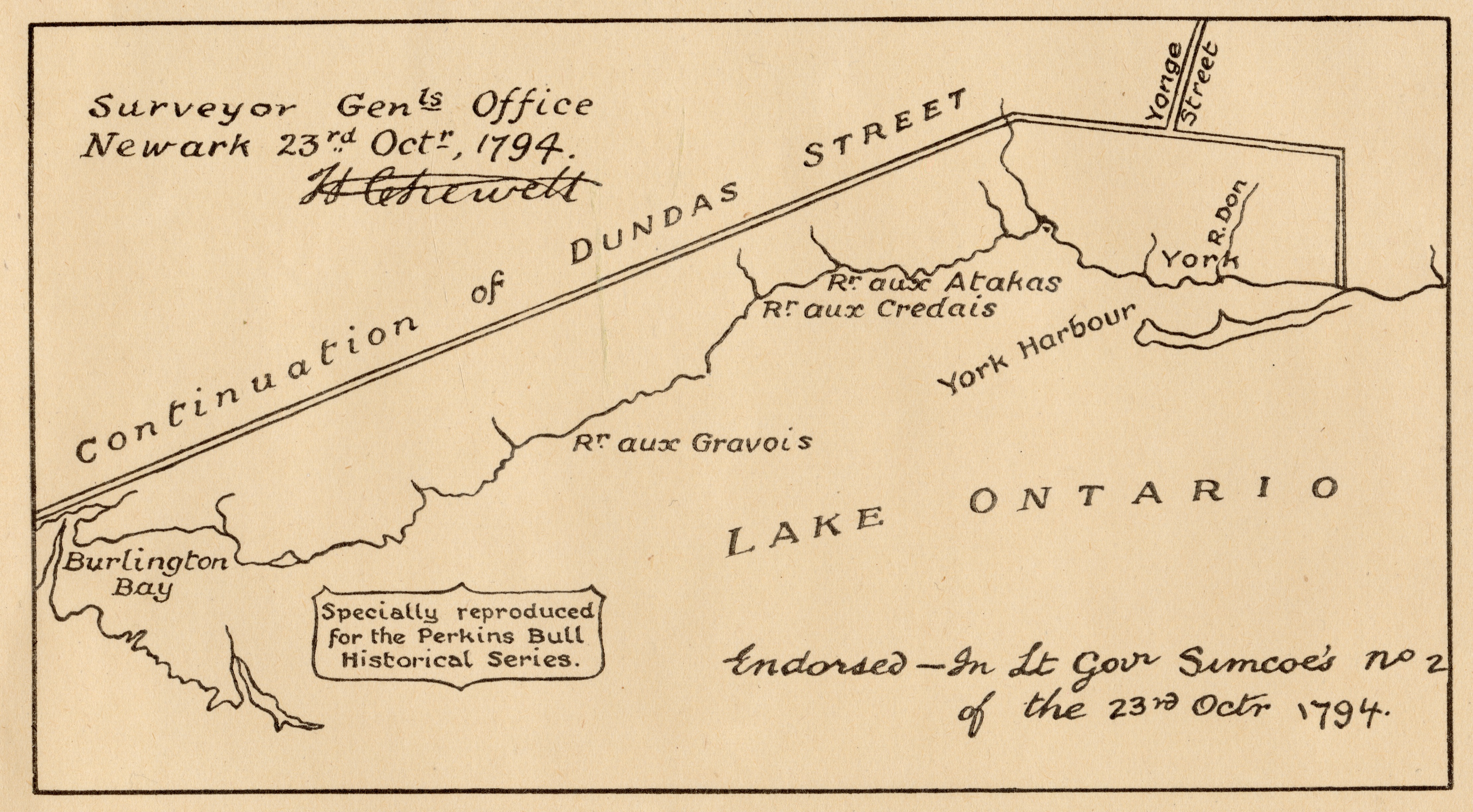
Drawing of Dundas Street, 1794, reproduced in the 1930s for Bull. In this drawing the Credit River is noted in French as “Rr. aux Credais”

Upper Canada, 1800, showing Dundas Street running through “Mississagues” lands (the future site of Halton and Peel Counties), Wm. Perkins Bull fonds, 2012.056

Canada West, 1854 showing major roads in Peel County (RPA map and plan collection, 2014.155)
One of the most interesting things I have learned during my research is that the modern day “Lakeshore Road” (constructed as King’s Highway #2 in 1917) does not, for the most part, follow the original route of the Lake Shore Road known to earlier Peel residents. For instance, Perkins Bull claims that by 1931 “all traces of it [the original Lake Shore Road] have disappeared through the greater part of Peel County.” He goes on to say that “what is now the Lake Shore highway runs along the old Lower Middle Road until somewhere between Lorne Park and Clarkson when it turns southeast towards the old Lake Shore road.” A map from 1955 helps to illustrate his point:

Segment from a 1955 map of Peel County, Russell Cooper fonds. The small piece of road in lot 28 in the lower left corner is a remnant of the original Lake Shore Road (my thanks to Heritage Mississauga’s Matthew Wilkinson for this insight!)
Hurontario Street (also known as King’s Highway # 10)
Writing in the mid-1930s Perkins Bull states that Hurontario (or the “Centre Road” as it was also known) “…has always been and still is the most important road in the county.” It was cut out from Dundas Street north to the then settlement of Brampton in 1820, with the first definite reference to it in newspapers appearing in 1826. By the mid-1830s the road appears to have been cut out north through the townships of Chinguacousy and Caledon, and by the 1840s the stretch within Toronto Township and Chinguacousy Township may have been macadamized. Its importance was due to it being the chief outlet for the farmers of northern Peel and beyond, including those working and living in Mono, Armanth, and Mulmur townships. Hurontario Street allowed those farmers to move their wares south to the harbour at Port Credit, thus granting them access to a larger market.
The constant use of this road led to it continually wearing down, and by 1848 portions of the macadam road surface were replaced with wooden planks.
Sixth Line / Mono Mills Plank Road (now Airport Road)
This road divided the Townships of Toronto Gore and Albion from the rest of Peel, and Perkins Bull argues that it was the “principle outlet for all traffic east of the Centre Road.” A private road company was formed in 1846 with its mission to macadamize or plank the road from Dundas Street to Mono Mills. It appears as if some or all of this work was completed because that company’s toll gate was in operation at the hamlet of Stanley’s Mills until 1873.
Gore and Albion Road
This road formed the eastern border of Peel County, and was cut out of the bush in 1825. In 1846 the Albion Road Company was formed to improve and maintain the road, and by 1850 there were 18 miles of plank road in place, starting near the settlement of Coleraine and running via Claireville, Thisteltown, and Weston, to Yorkville. Toll gates in Peel were built near Coleraine and Claireville. In 1885 the Claireville toll gate, the last toll gate in Peel, closed.
Erindale, Streetsville & Georgetown Road (now Mississauga Road)
West of Hurontario Street the most significant road was the one that originally connected the settlement of Springfield (later known as Erindale) on Dundas Road with the Village of Streetsville. The road appears to have been cleared in 1831, with no other serious improvement occurring until 1847 when the road was planked from Erindale to Harris’ Corners. A couple of years later it was planked all the way to Georgetown in Halton County. The tolls charged by the company overseeing the construction and maintenance led to an outcry by area citizens, with the Streetsville Review newspaper decrying the “brigandish toll bar which has been erected on Dundas Street at the foot of our plank road.”
Annotated road map, ca. 1931, Wm. Perkins Bull fonds, 2012.056. This map serves to illustrate one of Perkins Bull’s research techniques: he would mail out questionnaire forms and maps to a wide range of recipients (residents, professors, government officials, etc.) and ask them to return the material with their annotations. This map has been most usefully annotated by a respondent with popular names for various area roads.
Toll roads: The rise and fall of early privatization schemes
As has been hinted at above, early government officials in the Home District Council were quite keen to allow for the private construction and upkeep of roads. As a result, enterprising citizens could form road companies with the goal of building and maintaining specific roads. Once the road was macadamized or wood planked, the company would place booths manned by a toll collector at various points along the road.

The check toll gate, Dundas Street and St. Claire Avenue, Toronto, 1857, Wm. Perkins Bull fonds, 2012.056
The collected fares were supposed to go toward the upkeep of the road, but in practice it seems as if company officials opted to pocket the revenue, leading to a steady decline in the condition of the roads and an eventual takeover by area governments. As Perkins Bull comments:
“This practice of farming out the maintenance of the chief highways to some private company, and permitting it to finance itself by the collection of tolls here, there and everywhere along its route proved, however, to be most unsatisfactory.”
Toll roads in the area at one time or another included:
- Erindale, Streetsville & Georgetown Road (in operation 1847 – ca. 1861)
- Hurontario Street (1848 – 1857)
- Albion Plank Road / Gore and Albion Road (1846 – 1885)
- Sixth Line / Mono Mills Plank Road (1846 – 1873)
- Dundas Street (dates unknown, but there are two toll gates noted in the 1877 Peel County Atlas)
The establishment of the County Road System
One of the most significant turning points in the development of the modern road system came about in 1901, when the Province of Ontario decided to set aside $1,000,000 to support the construction of good quality roads throughout the province. Funds from this account would be made available to County Councils who established a “county road system” built and maintained according to regulations published by the province’s Department of Public Highways. In 1906, after much discussion, the County of Peel passed a bylaw establishing such a road system, and thereafter started to receive road funding from the province. Additional county bylaws were passed in the years that followed, designating more of the roads in Peel as County Roads.


Peel County bylaw 341 from 1906 and a road map of the County from 1932
Timeline of road network developments in Peel
To conclude I have compiled a timeline of road improvement “events” in Peel. I offer this with the proviso that at times the records offer conflicting information, and as such some of these dates should not be taken as necessarily being 100% certain.

Researchers interested in the history of roads in Peel are invited to visit the Peel Archives to consult the wide range of relevant records that we have in our possession.
Archival sources
Most of the information in this post was obtained from a number of road research files in the Transportation and Communication series in the Wm. Perkins Bull fonds (RPA 2006.139 and RPA 2012.056). Other useful sources included Peel County bylaws and Good Roads Committee reports (1906- 1924), and a newspaper article entitled “Peel County Good Roads System” published in the Brampton Conservator on August 19, 1915.
I would like to close by thanking Nick Moreau for providing the inspiration for this post, for all of his work creating the digital scans, and for severing the corduroy road video segment.
Kyle Neill, Senior Archivist
November 2021 edit: added a different version of the photograph of the roadworkers in Peel from the August 1915 issue of the Brampton Conservator.

Pingback: From mud to pavement: the early history of Peel roadways as told by our records — Archives @ PAMA | Hills of Heritage·
Hello! I am trying to find information on the potential for corduroy roads in historic downtown Brampton. It seems from this post that other sections in Mississauga were improved by macadamizing, but that in Brampton the road was not improved, since being cut out, until planks were put down in 1848-1850. Would this research have uncovered any mention, if it existed, of corduroy roads in Brampton? Otherwise, do you believe that the Brampton segment of Hurontaio/Centre was not a corduroy road?
LikeLike
Hi Eliza, thank you very much for your inquiry. From what I have read, I suspect that there would indeed have been corduroy roads in historic Brampton. Please email me at kyle.neill@peelregion.ca, thanks!
LikeLike
Pingback: Recent acquisition highlight: Peel railway records | Archives @ PAMA·
Pingback: The Archivist as detective: The use of “diplomatics” in a municipal archive | Archives @ PAMA·
Pingback: Researching the “woodland world”: Historic vegetation in Peel | Archives @ PAMA·
Pingback: Why I love government records | Archives @ PAMA·