


“Grandson, you can never hope to understand your world until you’ve understood the past.” Time Masters #1 (volume 2), DC Comics, 1990
To know the past…
As an archivist (and comic book lover!), I support the argument above that an understanding of the past is absolutely essential to understand the often complex ways in which prior events, forces, and ideas have shaped the present. By our very nature, archives (and the archival records that we hold) play a pivotal role in helping researchers uncover and map these historical complexities, so as to better understand the modern world and how it came to be.
However, it is interesting to consider that archival records themselves have their own fascinating, and at times complicated, histories as records. I contend that the context of creation and use of any given record, how it made its way into the Archives, and the often related connections it may share with other records, are all valuable details to ponder when conducting research.

It is also interesting to consider that records are not necessarily merely passive elements documenting a given story. Rather, they sometimes are themselves the story, depending on one’s perspective. For as archival practitioner and theorist Geoffrey Yeo has noted: “Record-making, of course, is not merely a matter of documenting or recording activities or events external to the recording process. Records perform activities. The making of a record is itself an activity and an event.”[1]
Record-making in Peel over time
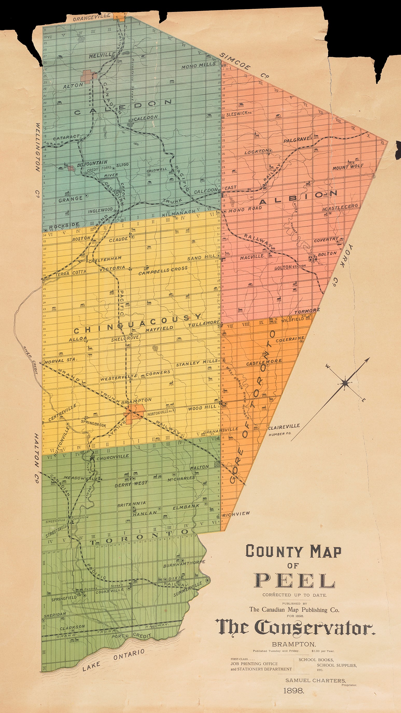
Peel has existed as a named municipal entity, in one form or another, since 1852. During its long history it has been home to the modern day municipalities of Mississauga, Brampton and Caledon (forming as they do the Region of Peel, 1974-present), but also their municipal forbearers, being a range of townships, villages, and towns that at one time or another made up the former County of Peel (1852-1973).


The composition of Peel, being a long-standing geopolitical administrative arrangement, has had an interesting and noticeable effect on the documentary heritage of the area. In short, there is a high level of interconnectedness between and among many of the groups of archival records in our care, both those created and collected by the local area governments, but also those created and collected by organizations, groups, and private citizens who have lived, worked in, or had an impact on the Peel area.
These interconnections are perhaps not surprising, given the often-shifting municipal borders within the historic Peel area, familial ties existing across internal township lines, the operation of historic and long-serving businesses and organizations with a Peel County/Region mandate or focus, and the shared participation in large scale municipal projects (such as waterworks).


A small sampling of material relating to “Peel” focused organizations or initiatives over the years
Peel’s archival legacies – connections across space and time
The level of interconnection between many of the records in our care demonstrates that the documentary heritage of the Peel area is more than the sum of its constituent parts, especially when the various record fonds and collections are arranged and described in relation to one another as part of a centralized Regional Archival program.

The remainder of this post shall explore some of my favourite records embodying this cross-Peel connection phenomena.
The Township of Toronto bench mark book photographs and the associated map index
One of my favourite groups of records is a series of 285 photographs created by Toronto Township planning department staff as part of their “bench mark book,” found within the Township of Toronto fonds (a municipal predecessor of the City of Mississauga). Each photo documents the location of small metal plaques known as “bench marks” positioned throughout the township. The bench marks, which were located on various buildings and structures, were used by planning staff to assist in situating other municipal projects.


However, the descriptions provided for each photograph were not user-friendly, and left much room for interpretation given the changed landscape of Mississauga over the past 66 years.
A Peel record connection to the rescue!
A few years ago we came across a file in the County of Peel fonds entitled “Bench Marks, cartographic, Toronto Township.” Among other things, the file contained two oversized maps which act as a confirmed geographical index for all of the 285 photographs, allowing staff and researchers to pinpoint, with accuracy, where every bench mark photograph was taken.


It is likely that Township staff forwarded the maps to their counterparts at the County, with the Township copies ultimately not surviving. But luckily for staff and researchers, the photographs and maps have now been happily (and usefully!) reunited.
City of Brampton road and culvert inspection reports
Those interested in historic culvert and railway crossings in the Brampton area would not be blamed for thinking that records speaking to their interest should be found among the archival records of the City of Brampton. And while there would indeed be some relevant material in the City of Brampton fonds, the single best source on this subject is found among the records of the Region of Peel!
Between 1974 and 1977 it appears as if a firm undertook an inventory and inspection of culverts throughout the Brampton area for the city. At some point thereafter, the city transferred these reports to the Region either for safekeeping or perhaps as reference material for related road projects of mutual interest. And at some point thereafter the records were transferred to the Regional Archives given their archival value. Either way, I am just very happy to have such a neat group of records available for users in the archives, notwithstanding the route they took to come into archival care.
Here are some examples of the reports, complete with their amazing accompanying photographs, not only of the culvert in question, but often the related roadways as well!


Tax assessment rolls for historic townships now forming part of a modern Peel municipality
Assessment rolls are records created and maintained by the municipality for property taxation calculation purposes – assessors travelled throughout the area recording the names of local property owners and tenants, as well as the current value of their land and buildings.

But what happens when those municipalities have their borders or very composition changed? As I mentioned earlier, the modern day municipal borders within Peel do not necessarily reflect historic ones. For example, property researchers in the Churchville area of the City of Brampton may be interested to learn that their land is actually legally defined as being tied to lots surveyed as part of the former Township of Toronto (given that the northern border of the modern City of Mississauga is not a straight line along Steeles as one might expect).


Similarly, researchers living in parts of the Malton neighbourhood of Mississauga would discover that their deeds link to lands in the Township of Toronto Gore and/or the Township of Toronto, because portions of Malton were contested between those former municipalities for some time prior to 1952.

And finally, the southern portion of the Town of Caledon was at one time better known as the north half of the historic Township of Chinguacousy. The modern border is, more or less, Mayfield Road, with some deviation in the Snelgrove area.

My point here is that the modern municipalities that make up Peel are themselves a result of amalgamations of former municipalities whose historic borders and responsibilities do not necessarily clearly align or map onto modern day borders. Thus, researching a modern “Brampton” or “Caledon” property or related issue may require an examination of assessment rolls and other records tied to former area municipalities, including the Township of Albion, Chinguacousy, and/or Toronto Gore. Thankfully, all of these separate (but related!) fonds are housed here in the Peel Archives.


Historic conservation and reforestation efforts throughout the Peel area
Patrons interested in historic reforestation efforts in Mississauga, Brampton and/or Caledon, would be best served by records kept by the County of Peel (the Region of Peel’s predecessor). The County’s Reforestation Committee tabled numerous reports, many of which provide insight into reforestation and conservation efforts, topics not necessarily covered in detail in the various lower-tier municipal fonds.
Here are some examples of Peel’s reforestation reports:


The larger image above is but the first page of a fulsome 1940 report on reforestation and conservation in Peel and can be downloaded here: Report of Preliminary Conservation and Reforestation Survey of Peel County, 1940 (Jan-Mar), County of Peel fonds. For more on the natural history of the Peel area please check out this post.
Newspaper photo morgues and print runs
The Peel area has been well served by local newspapers over the years, including the Streetsville Review, the Mississauga News, the Brampton Conservator/Guardian, the Bolton/Caledon Enterprise, the Peel Gazette, and others. Newsprint copies of such papers and their associated photo/negative morgues are invaluable assets when researching Peel’s past.
However, one should not necessarily allow newspaper titles to blind one to their true geographic scope! This is especially true with regard to the Brampton Times/Conservator and the Peel Gazette, which saw themselves as “County papers,” i.e. papers covering the entire Peel area, despite being headquartered in Brampton (incidentally the historic and modern Peel capital).

As a result, researchers interested in Mississauga or Caledon projects will often express surprise when we sit them down in front of the Brampton Conservator newspaper, and even more shock when all sorts of relevant articles start to appear!


The extensive research files of Peel’s unofficial historian, Wm. Perkins Bull
Probably the best single example of Peel’s archival crosslink phenomena has to be the extensive research files of Peel’s unofficial historian, Wm. Perkins Bull.

A lawyer and businessman, William Perkins Bull (1870-1948) was also a passionate and dedicated amateur historian. Starting in 1931, he and his extensive hired staff set out to document every facet of the County of Peel’s history. They travelled up and down the concession lines in all of the former townships, calling at homes, copying records, searching old photo albums, and interviewing residents. Bull also visited various archives and libraries, and corresponded with government agencies, professors, and subject experts.
His numerous books, unfinished manuscripts, and extensive raw research files reside with us and constitute an absolute treasure trove of information, of great use to genealogists, archeologists, academics, scholars, heritage planners, journalists, and any other researcher interested in the rich histories of the area.


The subjects covered in the fonds are wide-ranging, including such topics as natural history, the military, politics, immigration, Indigenous peoples, sports, religion, industry, temperance, and much more! The key point is that among any given subject file, researchers will be faced with a creator that was not necessarily concerned with hewing strictly to Peel’s then internal boundaries! Instead, they will often find a range of collected and collated material documenting large swathes of the Peel area in relation to the given subject, from the southern tip of what is now Mississauga to the northern end of what is now Caledon, and everything in between.


The above images are a selection from a single file of graphic material pertaining to assorted Peel area buildings and structures. This one file covers all the area townships, as well as the more specific communities of Erindale, Malton, Port Credit, Churchville, Grahamsville, Mono Road, Eldorado, Meadowvale, Snelgrove [Edmonton], and Castlemore/Claireville.
Given the extent of the mingling and cross-connections between and among the files and series in the fonds, there is no way to easily sever out or fully isolate material according to geographic demarcation. It is a true “Peel area” fonds, and a truly invaluable resource to those interested in the rich histories of Mississauga, Brampton, and Caledon as well as the former County of Peel.
The prolific photographic output of news photographer Russell Cooper

Russell (“Russ”) King Cooper was born in Brampton on January 18th, 1926, son of James Edward Cooper and Edith Hewetson. Cooper attended Brampton High School; Pickering College; and studied engineering at the University of Toronto.
From the late 1940s through the 1960s Cooper worked as a free-lance journalist and photographer for the Brampton Conservator, The Telegram (Toronto) and The Toronto Star. He also acted as a Peel County Constable and an OPP accident photographer. As a result, he spent a great deal of time snapping photographs up and down assorted township concession roads in Peel and beyond.

He was also active with various local groups/organizations, including the Peel Memorial Hospital Board of Governors, the Board of Governors of the Credit Valley School of Nursing, the Brampton Recreation Commission, the Grace United Church Sunday School, the Historical Records Advisory Board of the Credit Valley Conservation Authority, and the Peel County Historical Society.
The Russell Cooper fonds consists of records created and/or accumulated by Cooper, many the product of his photojournalism career, as well as others tied to his involvement in assorted community organizations.
The most referenced and utilized series by far are his thousands of photonegatives, because they offer up fantastic documentation of events and locales across Peel in the late 1940s and 1950s. For example, Cooper is our go-to source whenever we have any questions about the state or condition of specific area roads, because he documented a great many accident scenes, taking not only shots of the vehicles involved, but also the surrounding area.
Here is a small complilation of entries from the Cooper photonegative index, demonstrating the Peel breadth of the material:

Here are a few of my favourite photographic treasures found in the Cooper negatives:


The Peel Land Registry Office fonds
Since we are a professional archival program, with a clearly articulated, focused, and viable collection and service mandate, highly educated professional staff, a public Reading Room, and secure preservation facilities (including climate-controlled vaults), we are eligible to take on loans of archival records from the Province of Ontario. So, we are the proud recipient of a long-term loan covering the records of the Provincially-run Peel Land Registry Office, often shortened to LRO.

The LRO records date from 1806 up to about the 1950s, with more recent material still on file with the Province. The fonds consists of over 40 series of records, with the most prominent record types being:
- Memorial books
- Abstract indexes to deeds
- General registers
- Alphabetical indexes
- Instruments (deeds, mortgages, etc.)
- Copy books (handwritten or typed copies of the text in the instruments)

Taken together, the records in this fonds allow researchers to reconstruct the legal history of any piece of land in the Peel area as laid out in the original township surveys or subsequently in town or village lots.

However, as with the assessment rolls discussed above, these LRO records are structured around the historic townships within the County of Peel, all of which do not respect modern-day borders. So, some current residents of Mississauga may need to consult abstract indexes for Toronto Gore, as well as the Township of Toronto, some Caledon residents will need access to the Chinguacousy abstracts, and some Brampton residents will need Township of Toronto and/or Toronto Gore area records, etc.

Having the LRO material here allows us to truly be a “one-stop-shop” for any and all Peel area research, with researchers able to easily consult these land records in conjunction with area assessment rolls, directories, Wm. Perkins Bull research files, newspapers, and other related material currently in our care.
Records of two major Peel area School Boards
Finally, we act as the official archives for the Peel District School Board (PDSB) and the Dufferin-Peel Catholic District School Board (DPCDSB). The archival records created and collected by these boards and their numerous predecessors are an invaluable resource for not only those researching the history and evolution of education in the Peel area back to the 19th century, but also those interested in community and social history. Some of the main records groupings, many of which are protected by provisions in MFIPPA, include:
- School attendance registers for schools throughout all of historic Peel
- School Section/predecessor Board meeting minutes and related material
- Library catalogues
- Treasurer account/cash books
- Photographs
- Reports
- Yearbooks (for a small number of schools)

These education records are particularly useful when used in conjunction with other records held by the Archives. For example, please consider the range of records in our care that can be used when researching:
A family or person
- Attendance registers from the PDSB or DPCDSB fonds (if not closed by MFIPPA)
- Surname research files and photograph files found in the Wm. Perkins Bull fonds
- Property records from assorted municipal assessment rolls, tracking owners and tenants over time
- Property abstracts and instrument records from the Peel Land Registry Office fonds
- Relevant diaries or letters found in a private fonds
- A local telephone or landowner directory
- Local newspapers
A historic hamlet/community
- School trustee minutes re: size, financing and location of area school(s)
- School registers re: class sizes, teacher names, illnesses in area, local reminiscences (often teachers would include notes regarding local community events and history in the back of the general registers)
- Hamlet research files from the Wm. Perkins Bull fonds
- Photographs from the Russell Cooper fonds
- Local newspapers
- Women’s Institute local history scrapbooks
- A multitude of area maps from a variety of sources
Amidst some of the more routine school records, such as the attendance registers, library catalogs, and meeting minutes, can be found some outlier gems -here are three of my favourites from the PDSB fonds:
- A curriculum resource relating to Map Reading – Peel County, 1950 (S.S. No. 5 Albion), PDSB [now part of the Town of Caledon]
- Creative 1967: https://archive.org/details/creative-67-Toronto-Township a 1967 overview of all of the public schools in Mississauga at the time
- “The formation of the South Peel Board of Education,” 1963 (a fascinating history of one of the PDSB’s predecessor Boards of Education serving the southerly portion of Peel County)
As an aside, one of the more interesting summaries of the early days of education in Peel can be found in the research files of Wm. Perkins Bull.
Conclusion
I contend that this exploration of some of the gems in our collection has illustrated the utility, value, and elegance of the Peel archival program. Under our roof, any given researcher can access the archival records documenting the work of all current and former municipal governments as well as the two largest school boards in Peel, and can also make use of a wide range of other intricately linked records documenting the multifaceted history of the Peel area. The Peel archival collection is truly more than the sum of its constituent parts.
As a Peel archivist, I am grateful that I have been afforded the honour of being responsible for the identification, preservation, and provision of access to the richly interwoven documentary heritage of the Peel area.
By Kyle Neill, Senior Archivist
NOTES
[1] Geoffrey Yeo, “Record-making and record-keeping in early societies,” 2021, pg. xi


Greatly enjoy the Peel Archives blog – very interesting and informative – and a great resource in itself.
LikeLike
Thank you very much for reading our blog Richard!
LikeLike